Home
Click here to read my daily blog and see the exact route I took which was mapped by my Yellowbrick GPS Tracking System
Interview with the Pursuit Zone
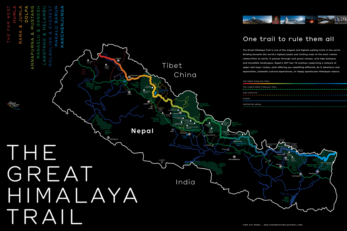
Between 1 April – 14 June 2013 I embarked on my 75 day, 1650km (including getting to and from the trail) solo trek from east to west Nepal along the Great Himalaya Trail (GHT). The majority of the trek was along the Upper GHT but where this was not possible due to technical sections or bad weather, I continued west on the Lower GHT. The upper sections completed were; Kanchenjunga, Sagamatha, Rolwaling (guide used for 1 day to cross the Tashi Labsta 5760m), Helambu, Ganesh, Manasalu, Annapurna, Lower Dolpa, Lake Rara, Mugu and Humla.
After taking 8.5 days to reach the start line at Kanchenjunga Base Camp (5130m), I started my 1480km adventure west to Hilsa, Humla on 9 April 2013. 64 days 2 hour and 35 minutes later on 12 June 2013 I reached the village of Hilsa to become the first person to walk solo across the GHT. Even though this was the finish line I still had a further 2 days walking (72km) back to Simikot, the District Centre of Humla, for my flight out of the moutons.
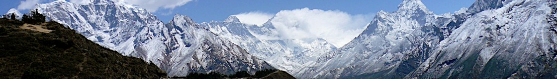
The whole expedition was a phenomenal and very privileged experience. My route went through some of the worlds most amazing and difficult landscapes that the world has to offer. I trekked through the Himalayan foothills, forests, jungle, varying villages and the Himalayas during all kinds of weather conditions. In total I walked over 13 x 5000+m passes and reached 2 x 5000+ base camps.
Throughout my time on the trail I completed a number of tasks too. I inspected a number of old school projects constructed by the Gurkha Welfare Scheme (GWS) and old Kadoorie Agricultural Aid Association (KAAA) projects such as bridges and micro-hydro. Additionally, I also identified potential future projects for KAAA, ranging from solar, micro-hydro and bridges to individual aid for the severely disabled. Throughout I also tried to promote the GHT and raise money for two very worth while military charities, the Gurkha Welfare Trust (GWT) and the Soldiers Sailors Airmen Families Association (SSAFA) Forces Help.
This trek would not have been able to happen it was not for the hard work and persistence from Khil Thapa from Gurkha Adventures and key members from British Gurkhas Nepal, GWS and KAAA. I would also like to say thank you to all of the team at the Great Himalaya Trail Development Program for their kind hospitality on completion of my trek and carefully listening to my recommendations for trail improvements.
Photo Compilation of East2WestNepal
In Jumla one week before finishing the GHT. At this point I had already walked around 1450 km.
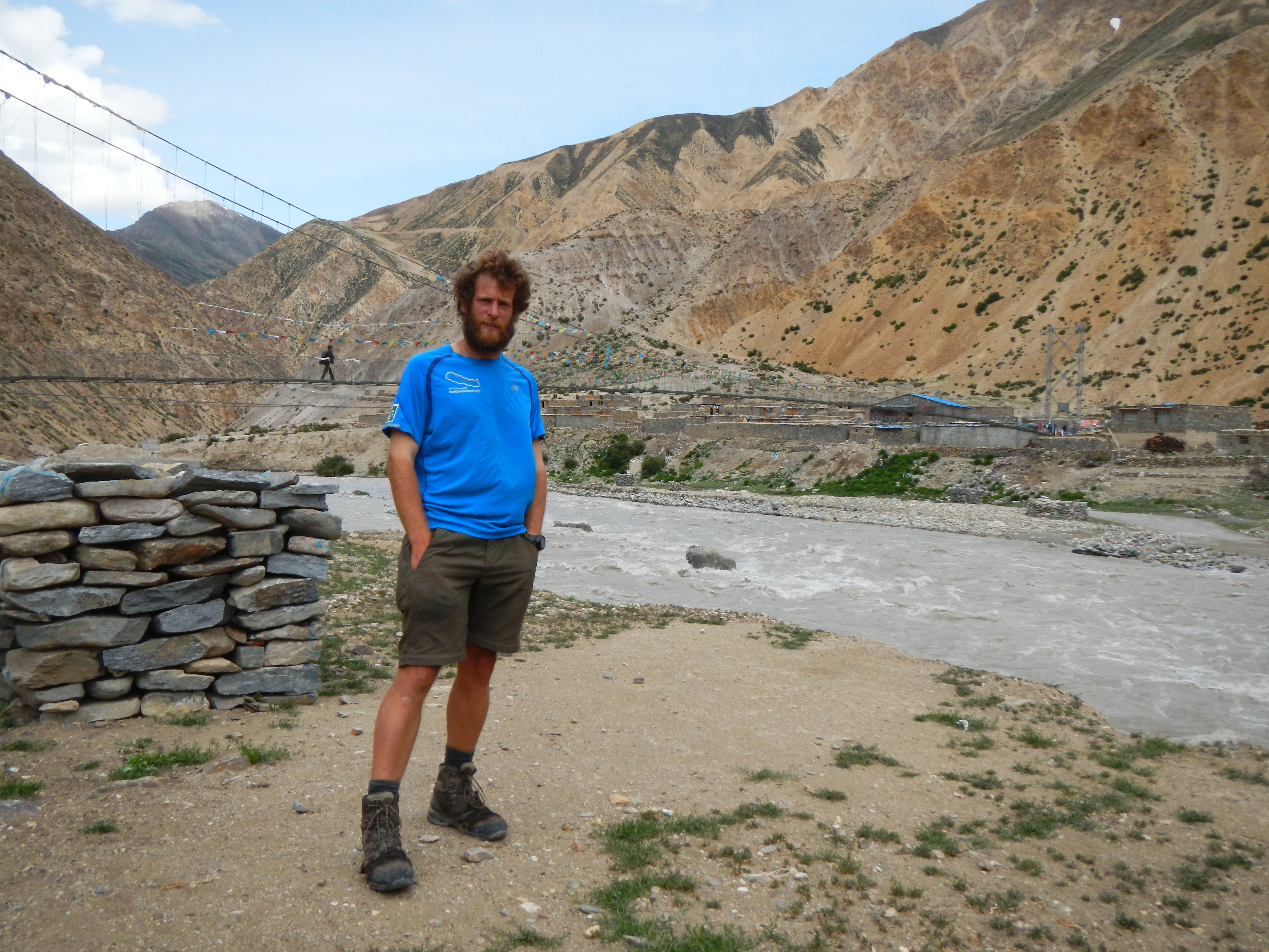
The official finishing point of the Great Himalaya Trail, the other side of Friendship Bridge. It had take me 64 days 2 hours and 35 minutes to walk the 1480km from Kanchenjunga Base Camp (although I had walked 1580km in 73 days in total including the time to get to the start point) . However, the walk wasn’t over, I had a 2 day 72km walk back to Simikot to get my flight out of the Himalayas.

Hi Doc,
Your experience is inspiring. I’ve been planning for a big hike overseas as I am from the US. The remote nature of the trek, the physical and mental challenge along with the opportunity to build relationships with the citizens of Nepal make this my number one choice. I am not opposed to a solo hike but am interested in a potential partner to help with planning and so forth. Do you know of any such forums to post for a potential partner?
Cheers,
Kenny (FL, USA)
kennyduffield@hotmail.com
Hi. I plan to start GHT Low route solo in September.
but I can not finde a good map of the GHT to plan my walking, do you know where to turn for this?
Hi Nino, great to hear that you looking at doing the Lower GHT, you will love it!
Regarding maps the ones I used were bought in Thamel in Kathmadu from the Himalaya Map House. However, you used to be able to buy them from http://www.thegreathimlayatrail.com but the website seems to be down. You can get the old SNV GHT Maps from Amazon which are expensive but they will give you something to plan with now and get better maps (a lot cheaper) in Nepal. I wouldn’t trek with these as they aren’t that good to read from on the ground. Let me know what you think. I have the old SNV maps somewhere, so depending on where you live I might be able to sell and send you them at a cheap rate.
Cheers
Doc
Hi Doc,
Very creditable achievment, you have done in GHT,that too Solo. I congratulate you on your Excellent Effort of Completing the GHT in a short time. Since I have done Little parts of the GHT ,solo,I am keen to do this full traverse of Nepal Section,solo. I have few Queries to you :
a) As Solo,how did you manage the Permits for the sections ( Issued only to Minimum two Persons)
b) Many sections require a Compulsory guide-how did you solve this problem
c) Among the sections, which has least Teahouses-so that a tent is a must ? or Is it possible to Manage the entire route without a tent or I have to scale down to the Lower GHT route. I want to avoid a Porter and at the same time dont want to carry a Heavy sack !!!! Being an Indian,can manage Nepali Food comfortably !!!I also plan to do the Makalu to Everest High GHT route in 2016 with two of my Friends,who are also qualified in Mountaineering, as a seperate trek,for 20 days.
Thanks in Advance
Wg cdr Sridhar Sridharan (Retd)
Sridhar, thanks for the message and the kind words. In short I got my permits through the organisation I used to work with as I did some work for them along the way e.g. checking projects. This is very difficult to get and unfortunately isn’t one that could be repeated easily. Best advice is to go through a trekking agency and get them to do the hard work for you, but as you said there are areas where you will have to have a guide/more than one person with you. But check on the latest advice from the Nepal Tourism Board, as this often changes.
The permit I got allowed me to walk solo, even though this was the case I still had troubles at some check points with the police.
Least teahouses……using my route as the example; western part of Kanchenjunga (west of Ghunsa) heading into Makalu, Lower Dolpo. Rest areas you can stay in homes. Note this will depend on how far you will walk each day. I would always push to get to a village where I could, however, this would often see me walking 10-14hrs. Tents are an additional form of safety from the elements. You could take a poncho/sheet to cover you from the elements however, a tent is a more robust option. I only used mine around 10 times in 74 days….. The kit I carried was heavy mainly due to the safety equipment I was carrying, tracking device, solar, sat phone, stoves, fuel, reserve food etc. You could do it lighter. A man recently did west to east nepal using a small bag, but he mainly did the lower route and I am note sure what equipment he had for safety if things wen throng etc.
Hope this helps!
Good luck
Doc
you are the strong man and lovely person of Nepal so I salute you.
Mira, thank you very much, it is very kind of you to say so.
Hey , Brave man ..!!!! , Doc Mckerr , It makes me waoo ..!!!! after read your experience from Great Himalayan Trail in Nepal Himalaya, which is awesome that you found somebody in Namche you deal with them personally and you complete such a great trail . seriously iam impressed from your post . I can able to find many field experience day to day itinerary from you. I am trekking guide from Nepal and i have been almost trekking region and those trail which is listed in great himalayan trail . I have a client (friend) who interested for the same itinerary as you did , since i haven’t been to all those region with the high passes i need someone to assistance me who have done complete Great Himalayan Trek . I got reply back from you to some other people in your post as a comment regarding the contact no. of your guide , but i can’t find his no . can you please send me his email that i can ask him if he is also free for me ? my email address is raj.oshovision@gmail.com. for the more information i am affiliated with one of the local company called NEST Adventure . it would be pleasure to meet your guide further information .
Hi Doc,
A fellow hiker who’s about to follow in your GHT footsteps. Together with a friend of mine, we plan on starting in Taplejung around the 12th of April, so just a bit later than your start.
I’ve been looking through your logistic information and it has been very helpful, however there are three questions that your insight could help us with.
– We’re planning to follow the same route as you did, thus making Tashi Lapsta our hardest pass to cross. This is also the part that is giving us the most doubts up until now. I read that you used a guide that you hired in Thame for this pass as well as rope, crampons and ice axe. My questions on this bit are numerous:
* Was it easy to find a guide in Thame and what was the cost? People in KTM told me they consider this a trekking peak, so they are talking about +300USD for a guide which seems a lot to me.
* In hindsight do you think the guide/rope/crampons/ice axe ware necessary?
* Would it be possible to rent the gear in Thame or do you consider the gear to be critical on other stretches as well?
– What’s your opinion Lumba Sumba pass? Any difficulties there?
– How did you connect the trail from Bharbise going into the Helambu area?
My main concern is with the first big question, but some advice on the last two questions would be great as well.
Thanks a lot,
David
Dave,
Thanks for your message and sorry for the delay. To make it easier I will answer your points in order:
– I got a guide through a hotel owner in Namche as he had a friend in Thame with climbing experience. I can get him to contact you if you want to? You could just arrive in the village and arrange it but it is always a risky option in case they are not available.
– 30m rope, crampons, snow stake, harness and axe are useful and can be hired from some of the Sherpa’s in Thame.
– This isn’t classed as a trekking peak as far as I know, but there is a peak next to the pass which is. This might be what they were referring to.
– The maps I had weren’t in sufficient detail for me to tackle this on my own plus the conditions were such that we needed an axe and crampons for part of the sections. The route itself is not difficult you just have to know where it is and where to go. Not that many people do this compared to other passes so it is difficult to get accurate knowledge of the route conditions, especially on the other side heading towards Nagoan, as this is where there could be crevasses.
– I cannot remember how much I paid, sorry, but I will get back to you. I don’t think it was more than US$300 though. My payment included the equipment, 2 guides (can’t just hire 1 as they need to go back over the pass after they have taken you to Nagoan). You will have to allow for between 4-6 days for their return journey depending on your speed.
– The Lumbha Sumbha is a great pass. I took a different reentrant to what was on the GHT Map, but this was because I couldn’t find it but felt comfortable taking the one I did do. It did however, been I extended my route somewhat making it a long very long day. The GHT maps are only 150:000 and are not great for navigating over the passes, I would recommend finding better ones if you can (I couldn’t find any) or printing Google Earth images. At the beginning of the day the weather was amazing for me, which was great but meant the snow melted early making it very hard work, however, the weather soon closed in going over the final pass (which isn’t marked with large cairns or prayer flags) but I was lucky that I managed to get a small weather gap in the clouds to go over. It is remote, but worth it. Just take extra care. I didn’t have equipment for this. Get details of the pass in Olungchun Gola if you can.
– Helambu area west of Simi Goan is very different to the areas you will have trekked before hand. The people are very different, less polite, more inquisitive and there are less actual tea houses. I just chose a route that linked some villages together on a route which I though would be the easiest to get me into the Langtang region. In this region you will notice a big increase in temperature as you are far lower, meaning that you will need to take on large amounts of water more frequently. Note that the route I took went through another national park which I wasn’t aware of called Gaurishankar Conservation Area, so make sure you have the right documentation as there is a check post in Laduk.
Once again sorry for the delay, I have been away. Feel free to ask me any more questions.
Good luck.
Doc
–
Hi Doc!
Thinking about doing GHT I just found your blog. Great job and fantastic expierience. i would like to ask you about two issues:
– How many permits and for which areas did you have when staring this trail? How much did all paperwork cost for the whole High GHT?
– In which areas did you have problems with police and why? Were there any places you were not able to cross? What was the reason?
Thanks a lot!
Luke
Luke,
Thanks for the message. If it is ok with you I will get back to you in the next few days after things have calmed down at university.
Regards
Doc
Luke,
Sorry for the delay.
Thanks for the message and its great that you are interested in doing the GHT or something similar in Nepal. Its a great trek and country and I highly recommend it.
In short, there are lots of areas which you will need to have permits for if you want to do the Upper GHT. The areas you will walk through are classified as National Parks and Restricted areas, both of which are governed by different organisations. This does make life that little bit more difficult I shall confess, especially because some of them like Kanchenjunga National Park, Mansalu National Park, Humla (restricted area) and Dolpo (restricted area) you need to have more than one person and a guide (no guide needed for Kanchenjunga though – just a min of 2 people). For up to date costs etc of these please see:
– Main Page: http://welcomenepal.com/promotional/travel-essentials/permits-fees-etc/
– http://welcomenepal.com/promotional/wp-content/uploads/2013/08/Entrance-Fees-to-Protected-Areas.pdf
– http://welcomenepal.com/promotional/wp-content/uploads/2013/08/Trekking-Permit-to-Restricted-Areas.pdf
I was very lucky because I was doing some charity work along the way I managed (although this was incredibly difficult to get) I managed to clearance to do the whole route without the need for individual permits. Currently the GHT Development Programme are keen to allow people to buy such permit from the National Parks and Restricted areas, but at present this doesn’t not exist. Each one would need to be bought prior to your trek or someone e.g. a trekking agency would have to buy them on your behalf and give them to you along the way (but would add to your costs).
Not that doing the Lower GHT (cultural route) has less restrictions with regards to permits and numbers travelling, so take a look at that too as a means of getting around the permit problem in the upper regions.
As there are a number of check points along the way manned by the police you cannot walk without them.
The main area I couldn’t cross, but wasn’t attempted as I highlighted this during the planning, were the passes in Makalu (Sherpani Col, West Col and Amphu Labsta) and the upper part of Langtang (Tilman Pass) as these are more technical and therefore I deemed not possible for me to do on my own. Especially as I wanted to be unsupported so would have had to carry full kit from the start. I didn’t do the Upper GHT through Upper Dolpo either as the weather was not great (poor visibility for most of the day) so went south-west via Jumla.
Finally, I did do the pass between Everest region and Rolwaling, Tashi Labsta, but with the assistance of a local as route finding is very tricky on the maps I had.
Hope this helps. Feel free to ask more questions if you want.
Regards
Doc
Hi, I can only confirm things you, Doc MrKerr, said in the last post. Crossing over the passes Sherpani Col, West Col and (in particular) Amphu Labsta requires mountaneering skills and attempting them on ones own would be foolishness. I was lucky with the weather conditions in 2012 and able to cross them, but nobody did so in 2013; according to all the reports; too much snow. If you have any questions about this section feel free to contact me either via FACEBOOK “Nepal-Great Himalaya Trail -walking for a better future” or via mail gmpau@online.no
That helps a lot! Thanks for this clarification, I will definitelly arrange the full set of permits in advance, so hopefully these problems won’t appear.
Hi Doc, I’d be interested to talk to you about your trek. Would you be willing to give me your e-mail address? I have some questions about doing this trip myself. Cheers 🙂
Hi Heather
I did the trip in 2012 ….. one of these “once in a life time adventures” regarding trekking. Though not easy it is worth all the hardship ;.)
Heather,
Thanks for the message. Feel free to send me an email to east2westnepal@gmail.com
Regards
Doc
Lia,
Thanks for the message. I will reply will more details over the comings days to your email account if thats ok?
Regards
Doc
What an amazing journey!! Congratulations!
What maps did you use? Did you find route finding challenging? How did you do food planning? It seems like you had some nights where you weren’t camped at villages and a few days were you went without seeing anyone.
I would love to thru-hike this too, but as a woman I’m a bit weary going solo! 😦
Lia, sorry for the delay. University is pretty busy at the moment.
I used GHT Maps which I bought at the Himalaya Map House in Thamel, Kathmandu (approx NCR 1000 each) – also see http://www.greathimalayatrail.com/ghtProducts.php . I bought the SNV GHT Maps through Amazon for my planning back in the UK, but these are not as good as the other maps and they are more expensive.
Route finding at times can be challenging especially in some places where the maps are not that accurate – although on the whole they are not too bad (scale is high though, 1:100,000 to 1:150,000). So long as you can see across the other side of the valley you should be ok, as you can use simple navigational checks to locate your position e.g. linear resections. The biggest problems were when the clouds covered the other side of the valley, I was in thick trees for hours at a time and when I was going over some passes where the scale was so large that not all of the peaks/features were on the map. I found route finding to and across the Lumbha Sumba Pass (Kanchenjuna National Park) very difficult because of the latter point and the fact the weather closed in rapidly too before I actually crossed the actual pass. The following day I got lost for two days between Thudam and Chyamtang because of poor large scale mapping, taking the wrong path and two days of bad weather.
I carried at least 4 days of simple food (some rice and noodles) with me at all times. However, I would always try and eat in villages to save time. This meant that I would walk long days in order to reach a village. I had planned roughly where I was going to do food resupplies too along the way prior to leaving the UK – based purely on some research and map appreciations. Note that the higher up the villages are, the less likely they are to either be occupied at certain times of the year or have much of a selection, if any. It also meant I could sleep inside which was great for relative comfort, time and security.
There were only a few times I would not see anyone for days. On the whole even if I hadn’t seen anyone during the day I would see someone at night in the villages. Although you are high up, the locals still use these paths for trade, grazing cattle and goats etc and for moving from one village to another – although time of year will dictate this.
Its a great trek to do. Naturally there are always going to be issues with doing any trek solo. There have been issues of people going missing in the past, however, these are not a regular occurrence. Due to the issue of permits, you would not be able to do all of the route that I did on your own. I did some work for a charity I used to work for when I lived in Nepal, so this is why I managed to get special dispensation for trekking through the areas I did. Even with my permit and the fact I speak Nepali, the Police in check posts along the way, sometime refused to let me through.
This aside, there are very few, if any permits required for the Lower GHT and you could trek through Annapurna National Park on your own.
Have you been in touch with the actual GHT programme at http://www.thegreathimalayatrail.org? They are a great team and were very helpful to me before my expedition.
Hope this helps.
Best of luck
Doc